Monday, October 15, 2018

BIHAR ECONOMIC SURVEY 2017-18


       BIHAR ECONOMIC SURVEY 2017-18
After placing the state's 12th Economic Survey Report on the House, Finance Minister Sushil Kumar Modi told  that Bihar is constantly moving forward in the economic sphere. The state's gross domestic growth reached 10.3% in 2016-17, which was 7.5% during 2015-16.

It is estimated to be 10.5% during the year 2017-18.
This national growth rate is more than 7%. During the last five years, the state's average growth rate is more than 10%. There are mainly two reasons behind maintaining the growth rate in two digits. First, capital investment in the public sector and second, along with improving the many critical points of the economy-related parameters,
Together, there is a fundamental improvement in the agriculture sector. Due to political stability, the state has been strengthened at the economic level.

Talking about the growth rate of the last decade, between 2004-05 and 2014-15 the state's income has increased at an average annual rate of 10.1%. It is the biggest indicator of economic strength.

This economic reinforcement has also seen direct impact on per capita income. Per capita income of the state was 31.6% in the year 2015-16 compared to the national average, which increased to 32.4% in 2016-17. It has registered an increase of one percent. During 2011-12, per person income was Rs 29,178, which increased to Rs 38, 546 in 2016-17.
Similarly, State Gross Domestic Product (SGDP) was 3 lakh 32 thousand crores in 2011-12, which increased to 4.88 thousand crores during 2016-17. During the last five years between 2011 and 2016, the state has registered an increase of 67.5% in the field of mining, 25.9% in manufacturing, transport, storage and communication in the area of ​​13.5%.
In all these areas, the growth rate has been registered more than 10% continuously.
State revenue surplus state for five years
Talking about financial health, it has been making a revenue surplus (revenue surplus) for five consecutive years. Revenue surplus is considered an indicator of better financial management. That is, the state has more expenses including salary, pension, capital expenditure
Compared to it, revenue receipts and debt get more money. The Finance Minister said that whatever the state government is taking, he is only spending on development works, While before 2005, the government took loans to pay salaries and pension. In the year 2016-17, the gross fiscal deficit has increased by 4,418 crores, while the 2015-


During the 16th, there was an increase of just 883 crore rupees. In addition to the development plans, basic infrastructure building, administrative and social spending has increased, due to the increase in the current financial year 2017-18, it is estimated to reach 18 thousand 112 crore. During the year 2016-17, the state had a debt of 21 thousand 577 crore,
Which is three thousand 194 million more than the previous year.
Other key points of economic survey
- Expenditure on development schemes in the state increased to 79% in 2016-17, compared to 2012-13. Revenue expenditure in development works increased from 35, 817 crores to 64, 154 crores.
- In this period less expenditure was incurred against development expenditure on non-development works.
It cost only 47%, which increased from 23 thousand 801 million to 34 thousand 935 million.
27% (5739 crores) spent in most energy sector in development works After this, 25% (5326 million) roads and bridge construction, 08% (1796 crore) irrigation and flood control work were spent. In the social sector, three thousand 592 crores were spent, Out of which 24% were spent on 32% improvement in health, water supply and sanitation and 30% in educational structures
Tuesday, October 9, 2018

Super 100 Geography Questions


geography के लिए इमेज परिणाम


1. Who first used the word Geographica for geography? - Eratosthenes
2. Who composed the book Meterologia? - Aristotle
3. What is the instrument measuring the direction and speed of the clouds? - Nephoscope
4. Where does the ophoseometer go? - In measuring distance
5.Which instrument is used for measuring high temperatures? - Pyrometer
6. What are the lines in the map where the pressure is equal? - subliminal lines
7. Which line is used to show the distribution of rain on the map? - Isohigh
8. When is the maximum distance between the sun and the earth? - 4th of July
9.Where is the largest volcano Olympus Mons? - on Mars
10. How many minutes does Sun light takes reach to reach the earth? - 8.3
11. When does the sun can be seen during Norway's Midnight? - 21st June
12.By the presence of which gas Neptune planet appears green? - Methane
13.What percentage of the total mass of the Earth is found in Mantle? - 68%
14. What is the name of the second layer from the top in three concentric layers of the earth? - Sima
15. What is the line joining the Earth's pivotal pole and the south pole? - Longitude
16. How long is the number of births? - 360
17.What is the difference between the local time of two places in crossing a longitude? - 4 minutes
18. Which is the highest peak of the continent of Antarctica? - Great Beer Lake
19. Which is the largest lake in the continent of Africa? - Victoria
20. In which country are the Java and Sumatra Islands located? - Indonesia
21.In which year did the theory of plate tectonics be presented? - 1960
22. Which Ocean is the largest number of submerged Kenyan? - Pacific Ocean
23. Which ocean is the largest extension of the Great Sea Plain? - Pacific Ocean
24. Which rock is found in coal? - laminated reef
25. Who made the Deccan Trap Shell Group? - Full-
Basalt ejaculation
26. What is called sea waves caused by intra-earthquakes? - Tsunami
27. Which volcano erupts? - Active volcano
28. What is the world's most volcanic field? - Philippine Islands
29. What is the origin of the Himalayas? – Tethys Sea
30.Which is the world's longest mountain range? - Andes
31. What is the property formed by the river erosion? - gorge
32. What is the topography related to which region of Lapis? - Karst
33. In which layer of cloud roaring the atmosphere? - The troposphere
34. Communications satellites are located in the atmospheric level? - ionosphere
35.Where do commercial winds run? - Fasting with high pressure
36. In which field do the low yields occur? - Equatorial linear area
37. What is the average annual rainfall in the world? - 100 cm
38. Which is the world's largest freshwater lake? - Victoria
39. In which country is the Vinufosfen waterfall situated? - Norway
40.What is the name of the canal located between Stockholm and Gothenburg? - Gota
41. Where are the spruce, fur and pine are mainly found? - in the taiga forests
42. What is known as the temperate angle of forest in Siberia region? - taiga
43. Which is the smallest ocean in the world? - Arctic Ocean
44. What is the highest depth of oceans (in meters)? - 11,033 m
45. Which river flows near which river Humboldt flows? - The. West coast of the US
46. ​​Aguladh Jaladhara is divided into two parts by which island? - Madagascar
47. 'El Niño Effect' is closely related to whom? - Equinox Resistance
48. Where does the world's highest tide come? - Gulf of Fondi
49. Tides rise in the oceans-
What is the reason for reflux? - Influence of the Moon
50. Who has introduced the progressive wave theory in relation to the origin of the tide? - William Wevel
51. Which river falls in the Caspian Sea? - Volga
52. Which is the largest river in South America? - Amazon
53. Hamburg is situated at the mouth of which river? - elb
54. Rome (Italy) is a town on the banks of which river? - Tuber
55. Budapest is situated on the banks of which river? - Danube
56. Who has rendered the land-based theory relating to the origin of coral reefs? Darwin
57. Which is suitable for the origin of the ocean coral? - tropical ocean
58.What is the highest salinity of ocean water? - near 35 ° latitude
59. Where is the Mediterranean climate not found? - In Bolivia
60. What is the Mediterranean region called? - Entrepreneurship Regions
61. Which of the following countries belongs to most of South Eastern Asia? - Monsoon Regions
62.In which natural state is the highest daily temperature? - The hot desert region
63. What is the winter rain in which natural state? - Mediterranean
64. What natural state is snowy throughout the year? - Tundra region
65. Where are the highest potatoes in the world? - Russia
66.Where are the wheat formations in Australia? - In New South Wales
67. Who is the world's largest tea producer? - India
68. Olive is grown in which broad area? - in France
69. Which country is the world's largest clove producer? - Zanzibar
70. Where is the cultivation of spring wheat? - In Russia and Canada
71.What is the main feature of gardening agriculture? - Efficient production
72. Which country is associated with Latan Dynasty? - Malaysia
73. What is the world's largest exporter of Nickel in the world? - Canada
74. What is the Mesabi range related to? - Iron ore
75. Who is the world's largest producer of silver? - Mexico
76.Where to go from Mumbai, will not have to go through the Suez Canal waterway? - Suez
77. What percentage of the total area of ​​the continents is domiciled? - 55% -60%
78. Where is the highest burden of population in the world? - Asia
79. According to an estimated 70% of the world population will be confined to the cities for the year? - 2050
80.World population day is celebrated? - 11 July
81. In which country is the highest mortality rate in Asia? - In Bangladesh
82. What is the continent with minimum population density? - Australia
83. What will be the world's estimated population in 2025 AD? - 8.0 billion
84. Which continent of the world has the highest population of primitive tribes? - Africa
85.Which tribes of people fall under the category of omnivorous? - Bushman
86. By what name are the inhabitants of New Zealand known? - keys
87. What is the ancient name of Malaysia? - Malaya
88. Which country's ancient name is Persia? - Iran
89. What is the ancient name of Zambia?
 - North Rhodesia
90. Which country is famous in the name of 'Second Newfoundland'?
- Japan
91. Which country is called 'the country of forests'?
- Democratic Republic of the Congo
92. Which country is known in the name of 'Swarnim Pagoda Desh'?
- Myanmar
93. Who is known as 'Land of Thousand Lakes'?
 - Finland
94. Which country is also known by the name 'White Peril Republic'?
- Belarus
95. Who is known as 'Silicon Valley of Malaysia'?
 - Penang
96. Which city is known by the name 'Great Hyelect Way' and 'Broad Way'? - New York
97. Which city is known by the quaker city 'Quaker City'? - Philadelphia
98. Who is called 'Silicon Valley of India'? - Begulluru
99. Which city  is Famous as “spain of Mumbai”? - Barcelona
100. Which continent is the largest in number of countries in the world? - Africa


Friday, October 5, 2018

All the important RIVERS OF BIHAR


rivers के लिए इमेज परिणाम
Rivers Of Bihar
River Ganga
Ganga is the most important river in India. This, in total, covers a distance of 2, 510 km in India and Bangladesh, from the Himalayas in Uttarakhand to the Sunderban in the Bay of Bengal, it irrigates vast terrain. Not only the natural wealth of the country, it is also the basis of people's emotional belief.
Length: 2,525 km
Estuary: Ganges Delta
Country: India
Source: Gangotri Glacier, Nanda Coat, Nanda Devi Mountains, More
Bridge: Mahatma Gandhi bridge, more
City: Haridwar, Varanasi, Allahabad, Patna, Kolkata, Kanpur, Ghazipur


Kosi river

The Kosi river or Kosi river flows from the Himalayas in Nepal and enters India via Bhima city in Bihar. There is a lot of devastation in Bihar due to the flood which is called this river 'Curse of Bihar'. If you look at its geographical nature, you will know that it has expanded 120 km in the last 250 years.
Length: 729 km
Flow: 2,
166 m³ / s
Source: Arun river, Tamur river, Sunkoshi river
Bridge: Koshi Mega Bridge Gandaul, Koshi Bridge Nepal
Country: India, Nepal
City: Katihar, Biratnagar, Purnia

BURHI Gandak


The Burhi Gandak is a river which appears between Ramnagar and Bagha in West Champaran of Bihar state of India. It flows through the districts of Eastern Champaran of Bihar, Muzaffarpur, Samastipur, and finally meets in Ganga near Khagaria. Wikipedia
Length: 320km
Country: India
Estuary: Ganges River

Gandak River
The river Gandak, which is also called the big Gandak or only Gandak, is the name of a river flowing in Bihar and Nepal. This river is called Saurabhrami or Sagramami in Nepal and Narayani and Saptagundki in the plains. The same is also known as the Condorcetes of the geographers of Greece and the Sadanira mentioned in epics.
Length: 630 km
Flow: 1,760 m³ / s
Source: Nhubine Himal Glacier
Country: Nepal
City: Jamsom, Sonpur, Lomangthang, Bagglung, Kagabni
Bridge: Keladighat Bridge

Ghaghara River

Ghaghra is a river flowing in northern India. It is the main river of river Ganga. It originates from the high mountains of southern Tibet, where its name is Karnali. After this it flows through Nepal and flows in Uttar Pradesh and Bihar of India.
Length: 1,080 km
Basin area: 127,950 km²
Source: Himalayas
Estuary: Ganga River
Country: India
Bridge: Karnali Bridge, Elgin Bridge

Mahananda River

 Mahananda River - This is the main Tributary  on the left bank of the Ganges. It is the last tributary  of the Ganga that runs from Himalaya. It forms Borderr of Bihar and West Bengal
Length: 360 km
Source: Himalaya
Estuary: Ganges River
State: West Bengal, Bihar
City: Siliguri, engrej Market
Country: India, Bangladesh

Punpun River

Punpun is a tributary of Ganges flowing in Bihar state of India. This river emerging from the hills of central Bihar makes the eastern boundary of Patna.
Length: 200km
Country: India
Estuary: Ganges River
City: Obra


Son river

The Son Nad or the Sonbhadra river passes through the Madhya Pradesh state of India and passes through the hills of Uttar Pradesh and Jharkhand, near Patna and join the Ganges River. It is a major river of Bihar. The name of this river is called Son because the sand of this river is yellow, which shines like gold.
Length: 784 km
State / Area: Baghelkhand
Source: Amarkantak
Country: India
Estuary: Ganges River
Bridge: koilwar Bridge

Falgu River


Falgu river originates from Palamu district of Jharkhand. This river does not flow with any other river. Falgu river goes to Jehanabad district and completes its flow. This river is found in the Methampi river in Bihar. 
Country: India
Estuary: Punpun River
Source: Mohana River, Lilajan River
City: Gaya


Karnashasha River

The river Karmanas is a river flowing in Jharkhand and Bihar. On this, there is the Devadri lane, whose height is 58 m. It has a mythical history too. It is said that the body of hung is related to the story of ascension.
Length: 192 km
Country: India
Estuary: Ganges River

Kamala River

Kamla river originated from Nepal and is mainly a river flowing in Bihar state of India. This river is considered to be the most sacramental and significant fertile power after the river Ganges in Mithilanchal.
Length: 328 km
Country: India
Estuary: Bagmati

Qeoull river


The river is the tributary of river Ganges. This   river  starts from Giridih district of Jharkhand and flows in Jamui and Lakhisarai districts of Bihar.
Length: 111km
Country: India
Estuary: Ganges River
State: Jharkhand, Bihar
City: Jamui, Lakhisarai, Qeouell junction

Mechi River

Mechi River is a river flowing through Nepal and India. It is the tributary of the river Mahananda. It emerges from the Mahabharata mountain range in Nepal and flows from Nepal and enters Bihar state, making border of India and Nepal, where it meets the Mahananda River in Kishanganj district of bihar.
Length: 80km
Source: Central Himalayas
Muhana: Mahindra river
Bridge: Mechi Bridge
Country: India, Nepal

Lakhandai River
Lakhandai is a river flowing in southern Nepal and Bihar state of India. It is a supporting river of Bagmati. In Nepal, the main stream of this river is 'Sarlahi Zilla' and its source is 'Shivalik Hills'.
Country: India
Estuary: Bagmati
Source: Nepal, Shiwalik


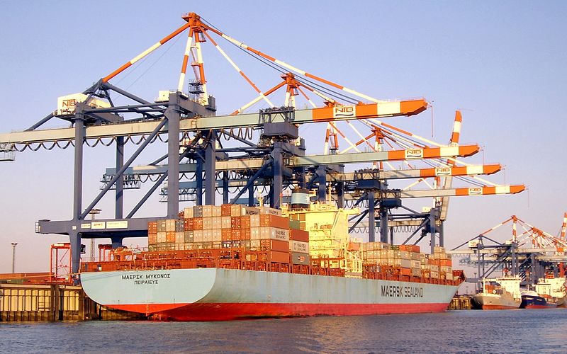
world's largest container shipping group AP Moller-Maersk

container shipping Ap moller maersk के लिए इमेज परिणाम

Why in the discussion?

The  world's largest container shipping group AP Moller-Maersk has successfully completed the test journey through the Russian Arctic.

The ship arrived from Vladivostok, Russia in the North Pacific Ocean on 22 August and reached St. Petersburg, located on the Gulf of Finland.
This sea route can become a new highway between Asia and Europe.


This route reduces the distance between Eastern Asia and Western Europe (currently Malacca Strait, Indian Ocean, via Eden Bay and the Suez canal), from 21,000 kilometers to 12,800 kilometers. In this new route, only 10-
It will take 15 days

Arctic ice disappeared

Over the years, melting sea ice has opened this route for ships.
Measurements show that since the late 1980s the sea ice covering the Arctic ocean has been declining year after year.
As a result of climate change, warming occurs in very high speeds in parts of the Arctic. Evidence of frozen ice and its thick layer disappeared for years.

New naval route
Due to the increase in sea temperature, it can be assumed that by the middle of this century, ships will be able to move from north to Russia and reach the northern part of Canada directly as the North Pole.
There is a significant increase in the nine-transportation activity in this region in the next decade,
Because Russia is likely to develop oil and gas related areas in Siberia.

Arctic route issues

Cost
♦ High costs and the changing conditions of Arctic ice can discourage operators. To cope with these situations, strict criteria may have to be followed.
Security
♦ Keep in mind the worries of increased insurance costs and safety concerns.

Environment

Ships and pollution generated by ships can seriously affect marine life in the environment as well as in other parts of the ocean world.

AGRICULTURE OF BIHAR

agriculture के लिए इमेज परिणाम


Bihar lies in the river plains of the basin of the river Ganga. It is endowed with fertile alluvial soil with abundant water resources, especially ground water resources. This makes the agriculture of Bihar rich and diverse. Rice, wheat, and maize are the major cereal crops. Arhar, urad, moong, gram, pea, lentils, and khesaria are some of the pulses cultivated in Bihar. Bihar is the largest producer of vegetables, which is dominated by potato, onion, eggplant, and cauliflower. In fruit cultivation, it is the largest producer of litchi and the third largest producer of pineapple, as well as a major producer of mango, banana, and guava. Sugar cane and jute are two other major cash crops of Bihar.
Rainfall and soil
The average rainfall in Bihar is 1053 mm. The rainfall in Bihar is largely due to the south-west monsoon, which accounts for around 85% of total rainfall in the state. The other sources (winter rain, hot-weather rain, and the north-west monsoon) account for the remaining 15%. The average normal rainfall in the state is more or less adequate for its agricultural operations. However, year-to-year changes lead to drought or flood, causing extensive damage to the crop production and the overall income of the state.
Bihar has a geographical area of 9,360,000 hectares with three important agro-climatic zones: North-West, North-East, and South. The North-West zone has 13 districts and receives an annual rainfall of 1040–1450 mm. The soil is mostly loam and sandy loam. The North-East Zone has 8 districts; it receives rainfall ranging from 1200–1700 mm, and has loam and clay loam soils. Finally, the South Zone (17 districts) receives an average annual rainfall of 990–1300 mm. Its soil is sandy loam, loam, clay, and clay loam.

Cropping pattern

The net sown area in Bihar is 60% of its geographical area. This percentage is much higher than the all-India average of 42%. Such a high percentage of cultivated land is possible for two reasons. First, most of Bihar is plain area suitable for agriculture. Second, most of the forest had been converted into farmland during the last 2000 years. Currently, land under forest constitutes only 6% of the area.


Food grains

Rice is cultivated in all districts of Bihar. Autumn rice, aghani rice, and summer rice are three different varieties of rice grown at three different times of the year. The average production of rice is around 5 million tonnes each year. Some five decades back, wheat cultivation was very restricted to western districts of Bihar. After green revolution success, wheat was planted by Bihari farmers on a larger scale, and wheat now occupies the status of major crop of the rabi (spring) season. The average annual wheat production is approximately 4-4.5 million tonnes. Maize is also cultivated, with an average annual production level of approximately 1.5 million tonnes and a steady positive trend in production. The leading producer districts are Khagaria and Saharsa. Pulses such as moong, arhar, peas, and khesari are grown, more in southern than in northern Bihar. The leading districts are Patna, Bhojpur, Aurangabad, and Nalanda.

Vegetables

The total area under vegetable cultivation is currently about 11% of the state's gross sown area, and is increasing. The important vegetable crops include potato, onion, tomato, cauliflower, and brinjal. Hajipur in Vaishali is famous for an early variety of cauliflower that reaches market in the last week of September. Production of vegetables is well dispersed over the districts, with a concentration of production in some particular districts. Apart from Patna and Nalanda[Jehanabad] , where vegetable production is quite extensive, the other districts with high shares in total vegetable production are Vaishali, Muzaffarpur, West Champaran, East Champaran, Katihar, and Begusarai


                                                         बिहार का कृषि

बिहार गंगा नदी के बेसिन नदी के मैदानों में स्थित है। यह प्रचुर मात्रा में जल संसाधनों, विशेष रूप से भूजल संसाधनों के साथ उपजाऊ जलोढ़ मिट्टी के साथ संपन्न है। यह बिहार की कृषि समृद्ध और विविध बनाता है। चावल, गेहूं, और मक्का प्रमुख अनाज फसलों हैं। अरहर, उरद, मूंग, ग्राम, मटर, मसूर,
और खेरिया बिहार में खेती जाने वाली कुछ दालें हैं। बिहार सब्जियों का सबसे बड़ा उत्पादक है, जो आलू, प्याज, बैंगन और फूलगोभी का प्रभुत्व है। फल की खेती में, यह लीची का सबसे बड़ा उत्पादक और अनानस का तीसरा सबसे बड़ा उत्पादक, साथ ही आम, केले और अमरूद का एक प्रमुख उत्पादक भी है।
चीनी गन्ना और जूट बिहार की दो अन्य प्रमुख नकदी फसलें हैं।

वर्षा और मिट्टी
बिहार में औसत वर्षा 1053 मिमी है। बिहार में बारिश दक्षिण-पश्चिम मॉनसून की वजह से है, जो राज्य में कुल वर्षा का लगभग 85% है। अन्य स्रोत (सर्दियों की बारिश, गर्म मौसम बारिश, और उत्तर-
पश्चिम मानसून) शेष 15% के लिए खाते हैं। राज्य में औसत सामान्य वर्षा अपने कृषि संचालन के लिए पर्याप्त या कम पर्याप्त है। हालांकि, वर्ष-दर-वर्ष परिवर्तन सूखे या बाढ़ के कारण होते हैं, जिससे फसल उत्पादन और राज्य की कुल आय में भारी नुकसान होता है।

बिहार में भौगोलिक क्षेत्र 9,360,000 हेक्टेयर है जिसमें तीन महत्वपूर्ण कृषि-जलवायु क्षेत्र हैं  :-उत्तर-पश्चिम, उत्तर-पूर्व और दक्षिण। उत्तर-पश्चिम क्षेत्र में 13 जिलों हैं और 1040-1450 मिमी की वार्षिक वर्षा प्राप्त होती है। मिट्टी ज्यादातर लोम और रेतीले लोम है। उत्तर-पूर्व क्षेत्र में 8 जिले हैं; इसमें 1200-1700 मिमी से वर्षा होती है, और इसमें लोम और मिट्टी की लोम मिट्टी होती है। आखिरकार,दक्षिण क्षेत्र (17 जिलों) में औसत 9 0-1300 मिमी औसत वार्षिक वर्षा होती है। इसकी मिट्टी रेतीले लोम, लोम, मिट्टी, और मिट्टी लोम है।


फसल पैटर्न
बिहार में शुद्ध बोया क्षेत्र अपने भौगोलिक क्षेत्र का 60% है। यह प्रतिशत अखिल भारतीय औसत 42% से काफी अधिक है। खेती की भूमि का इतना उच्च प्रतिशत दो कारणों से संभव है।
सबसे पहले, बिहार का अधिकांश हिस्सा कृषि के लिए उपयुक्त सादा क्षेत्र है। दूसरा, पिछले 2000 वर्षों के दौरान अधिकांश जंगल को कृषि भूमि में परिवर्तित कर दिया गया था। वर्तमान में, जंगल के नीचे भूमि क्षेत्र का केवल 6% है।

अनाज
बिहार के सभी जिलों में चावल की खेती की जाती है। शरद चावल, अग्नि चावल,
और ग्रीष्मकालीन चावल साल के तीन अलग-अलग समय में उगाए जाने वाले चावल की तीन अलग-अलग किस्में हैं। चावल का औसत उत्पादन हर साल लगभग 5 मिलियन टन है। लगभग पांच दशकों पहले, गेहूं की खेती बिहार के पश्चिमी जिलों तक ही सीमित थी। हरित क्रांति की सफलता के बाद, बिहारी किसानों द्वारा गेहूं को बड़े पैमाने पर लगाया गया था,
और गेहूं अब रबी (वसंत) मौसम की प्रमुख फसल की स्थिति पर कब्जा कर लेता है। औसत वार्षिक गेहूं उत्पादन लगभग 4-4.5 मिलियन टन है। मक्का भी लगभग 1.5 मिलियन टन के औसत वार्षिक उत्पादन स्तर और उत्पादन में एक स्थिर सकारात्मक प्रवृत्ति के साथ खेती की जाती है।
प्रमुख उत्पादक जिले खगरिया और सहारसा हैं। मूँग, अरहर, मटर, और खेसरी जैसे दालें उत्तरी बिहार की तुलना में दक्षिणी में अधिक उगाए जाते हैं। प्रमुख जिले पटना, भोजपुर, औरंगाबाद और नालंदा हैं।

सब्जियां
सब्जी की खेती के तहत कुल क्षेत्र वर्तमान में राज्य के सकल बोए गए क्षेत्र का लगभग 11% है,
और बढ़ रहा है। महत्वपूर्ण सब्जी फसलों में आलू, प्याज, टमाटर, फूलगोभी, और बैंगन शामिल हैं। वैशाली में हाजीपुर फूलगोभी की शुरुआती किस्म के लिए प्रसिद्ध है जो सितंबर के आखिरी सप्ताह में बाजार तक पहुंचता है। कुछ विशेष जिलों में उत्पादन की एकाग्रता के साथ, जिलों में सब्जियों का उत्पादन अच्छी तरह से फैल गया है
। पटना और नालंदा [जहांनाबाद] के अलावा, जहां सब्जी उत्पादन काफी व्यापक है, अन्य सब्जियों के उत्पादन में उच्च शेयर वाले अन्य जिले वैशाली, मुजफ्फरपुर, पश्चिम चंपारण, पूर्वी चंपारण, कटिहार और बेगूसराय हैं।